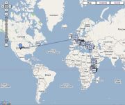
Being the super-nerd that I am, after Flickr came out with their new photo map, I caved to an idea my friend Clint had suggested at the beginning of my trip and bought a small GPS unit to use in geotagging my photos, so that they will now automatically show up on the map at the exact spot that I snapped them. For anyone else interested in doing this, here is a good primer on geocoding using the same GPS receiver I picked up; for the technically inclined.
My camera caused a bit of trouble with the 'Time Zone', so if anyone does actually decide to give this a try and runs into any issues feel free to shoot me an email and I can let you know what I had to do to finally get it going.
My camera caused a bit of trouble with the 'Time Zone', so if anyone does actually decide to give this a try and runs into any issues feel free to shoot me an email and I can let you know what I had to do to finally get it going.


2 comments:
i just spent a half an hour perusing your photos...they're amazing. you're a great photographer (though you have been provided with some pretty photogenic material :))
Speaking about "geotagging": do you know locr?
locr offers the ideal solution and makes geotagging exceptionally easy. locr uses GoogleMaps with detailed maps and high-resolution satellite images. To geotag your photos just enter address, let locr search, fine-tune the marker, accept position, and done! If you don't know the exact address simply use drag&drop to set the position.
For automatic geotagging you need a datalog GPS receiver in additon to your digital camera. The GPS receiver data and the digital camera data is then automatically linked together by the locr software. All information will be written into the EXIF header.
Use the "Show in Google Earth" button to view your photos in Google Earth.
With locr you can upload photos with GPS information in them without any further settings. In the standard view, locr shows the photo itself, plus the place it was taken. If you want to know more about the place where the photo was taken, just have at look at the Wikipedia articles which are also automatically assigned to the picture.
Have a look at www.locr.com.
Post a Comment